Memberberries

When I decided to move to Greenville from Charleston, I knew I had to say goodbye to my beautiful single speed beach cruiser (her name was Lulu) and find a new steed that was more compatible with rolling hills. I was evidently so worried about finding a bike shop in Greenville (ha) that I looked up Affordabike on King street, and fell in love with Oliver. He made the journey to Greenville with me and we had a great many adventures together. Suddenly no longer limited by geographical barriers such as bridges or bodies of water, it was with Oliver that I began to explore the possibility of living car free permanently, rather than going a few weeks at a time without driving.


Unfortunately, our love was not built to last. As beautiful as he was, the hills were calling and he weighed a hefty 42 pounds.  Being exposed to the road cycling culture of Greenville made me realize there was a more efficient way to get around. After just 6 months, I bought a touring bike and eventually sold Oliver since I simply don’t have room in my apartment to keep him.  As nostalgic as I can get about my past bikes, I like to imagine them continuing on their journey and bringing joy to other riders.

Memberberries

Lend me your ears

I’ve been enjoying The Spokesmen podcast since re-discovering it this summer, but this week’s crossover episode by Off Peak about the history of roads in America is exceptionally fascinating. Seriously, go listen to it!

I thought I knew a good bit about the history of roads, but I wasn’t aware it involved mastodons or germ theory. I also loved the part where cars were called “noisy smoking stinkwagons” (also, I think that would make a great bumper sticker). It’s so interesting to see how our perception of what is “normal” and acceptable to society can be altered, especially in terms of infrastructure that we typically take for granted and tend to assume has never or hardly changed. And with all of the recent buzz about self-driving cars, it’s intriguing to think about how our relationship with public roadways could change in the next few decades.


Lend me your ears

Biking the GAP and C&O trails

So back in July I rode from Pittsburgh to DC over 6 days with my dad. I’ve been meaning to post about the trip but it’s pretty daunting to try and cover all of the details we collected over our journey.

But it’s almost November, so clearly I need to just get over the fact that this post isn’t going to be the perfect tell-all guide to the GAP/C&O that I had envisioned. But if it inspires some bike travel, I’ll be satisfied with that. I took approximately one billion pictures, but in order to not break the internet I’ll just post some highlights here.


screen-shot-2016-10-31-at-7-03-54-pm

Continue reading “Biking the GAP and C&O trails”

Biking the GAP and C&O trails

FAQ: Does that take you forever and a day?

One of the visions I had for this blog was to write about questions I get asked all. the. time. The funny thing about lifestyle changes is that once you get used to a new or different way of doing things, you often don’t even think twice about it.

So I’ll start off with a common one, which is how long it takes me to get from A to B versus driving. It really depends on where you are, which is one of the things that makes answering this question kind of tricky. Getting a feel for local roads is something that also just takes some time and getting used to, and it took me baby steps over the last 7 years to get used to. After all, most Americans spend our lives from a four-wheeled, car centric viewpoint that we typically take for granted.

What surprised me years ago when this all began was that in an urban setting biking is actually the fastest way to get around. It’s one of the aspects of cycling that wooed me into buying a pawn shop bike in Vienna while studying abroad (that and the 50 euros a month for a transit pass was far more than buying and selling back a bike). Even in a city with one of the best public transit systems in the world, I could get from our student house in the city suburbs to the middle of the Ringstrasse with 10-15 minutes to spare before the rest of the class joined up via bus/subway/streetcar.

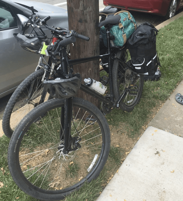
When you factor in time for finding parking in a city and then walking from the garage to your destination, biking from the outskirts into a downtown location is also often the most efficient method of transportation. The efficiency decreases as distance and average speed limits increase, and often a 10 minute drive in a suburban area equates to a 30 minute bike ride, and this summer 252 miles broken into a 3 day trek across South Carolina was a disheartening 3 hour drive back when it was over.

When it comes to work, what would be a 5 minute drive in a car is under a 15 minute bike ride, following the “x3” rule of thumb. Last year I had a much longer commute across town that took a combined hour between biking and the bus, but if I’d driven I’d have had to allow for an interstate disaster and allotted myself at least 30 minutes, really 45 to be on the safe side.

The best way of figuring out how long different routes would take is the Google Maps bike feature. I’ve found that this calculation tends to assume you are on a mountain bike or city cruiser going an average 12 mph, so on a road bike I almost always shave off a few minutes from the projected time.

You can also check out the recommended cycling routes in your area using the “bicycling” feature on Google Maps and determining your own route. When I first moved to Greenville I scoped out some of these roads in my car before exploring them on my bike, but street view is also a handy tool for getting a feel for different roads. Dark green means a dedicated bike path, lighter solid green is a bike lane, and dotted lines mean sharrows or a recommended lower traffic route. I’ve included a screen shot of Greenville for an example:

screen-shot-2016-10-08-at-10-40-37-am

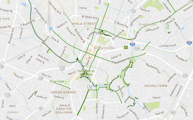
Generally more stores and development mean more traffic, and for Greenville this holds true as the east side of town near the interstates is a traffic clogged nightmare (also where you’ll find the mall, car dealerships, Costco, Target etc), whereas the west side of town is (for now) relatively quiet and it’s generally much easier to share the road.

Finally, avoid Apple maps at all costs, because until they have similar technology, Siri will not understand anything in between walking and driving speed and will lure you to an untimely death by trying to reroute you onto a highway if you’re moving anywhere above 5 mph.

Alternatively, this could be summed up as:

Q: Wow how long does it take you to ride your bike there?

A: Not really that long, I don’t have to worry about a standstill on an interstate, and I never have to pay for parking 🙂

FAQ: Does that take you forever and a day?

We need more trail yesterday

It’s great to hear from people who want to bike commute in their town, and even better when it’s local people who I can share personal experience with on specific routes and ideas. What’s not so great is when the answer is something like, “well I do it, but most people would never reach that level of crazy”.

This article from Bike Walk Greenville recounts an email exchange I was cc’d on last week from a newcomer to Greenville who is interested in a commute similar to what I traversed last year. On the one hand, there are some options to consider and we are lucky to have a reliable, albeit massively underfunded, bike friendly public transit option to supplement a bike commute. On the other hand, without protected bike lanes, low traffic bypasses or better yet a bike trail network, we are stuck with a community design that says to people “you’d better get in your car and stay there, if you want to live.”

Thankfully, the planned Swamp Rabbit Trail extension has huge potential to transform the Southeast concrete jungle of Greenville from a gridlocked mess into a highly desirable area to live as well as work and shop. We need this kind of connective infrastructure yesterday, and I can only hope that sooner than later, we will learn some valuable lessons to apply toward future development as Greenville continues to grow.

We need more trail yesterday

Sweater weather

It’s been a whirlwind getting back to a new school year at my new location. At the end of last year I was offered a position just 2 miles away, so my days of getting up at 5:45 to trek to the other side of town are swapped for relatively easy mornings with a quick and easy commute. Once things become a little more routine I expect to finish up some notes on my summer trips to Mexico and my bike tour from Pittsburgh to DC.. But, priorities.

Like accessorizing my commuter. I was tired of looking at my sad chain stay sticker, and inspired by a Lizard Skins neoprene and velcro cover, so I thought why not knit a sort of coozie for it?


I cast on 12 stitches onto size 4 needles, knit in stockinette stitch about 8.5″, cast off and sewed it on since I wanted it to lie flat. So far so good, I’m sure eventually it will get grungy to the point that I’ll cut it off and replace it. It was quick and easy to make, so worth the experiment to me.

Most importantly, my bike will be snug and ready for fall weather. She just needs a pumpkin spice latte in her bottle cage..

Sweater weather